
Agroforestry map of Europe – moving from a basic map to an advanced database
Oral presentation – EURAF2024 – 28-31 May 2024 – Brno Dr. Rico Hübner¹, Matthias Tylkowski²1 Deutscher Fachverband für Agroforstwirtschaft (defaf) E.v., Cottbus, Germany2 duktil UG, Cottbus, Germany Mapping of agroforestry examples revealing information on trees and shrub species and their combination with animal husbandry and crops, including planting layout, business strategies, and respective photographic impressions is of great interest to the public, experts, and farmers.To further spread the concept of agroforestry as a promising land-use system and convince farmers bylearning from the experience of their peers, the European Agroforestry Map was initially developed in theAGFORWARD project (2014-2017) (Palma, Crous-Duran…
Oral presentation – EURAF2024 – 28-31 May 2024 – Brno
Dr. Rico Hübner¹, Matthias Tylkowski²
1 Deutscher Fachverband für Agroforstwirtschaft (defaf) E.v., Cottbus, Germany
2 duktil UG, Cottbus, Germany
Mapping of agroforestry examples revealing information on trees and shrub species and their combination with animal husbandry and crops, including planting layout, business strategies, and respective photographic impressions is of great interest to the public, experts, and farmers.
To further spread the concept of agroforestry as a promising land-use system and convince farmers by
learning from the experience of their peers, the European Agroforestry Map was initially developed in the
AGFORWARD project (2014-2017) (Palma, Crous-Duran et al. 2015, Burgess and Rosati 2018) and continued by EURAF (2024). In the meanwhile, organizations in several EU countries and regions developed databases and maps within their activities, such as in France, Flanders, and the Netherlands, or by partners in the LIFE AgroForAdapt (2024) project for parts of the Mediterranean. The attempt of the new agroforestry map of Europe is to bring these activities together in a uniform layout to summarize, visualize, and explore the online map across Europe and in English language.
There are different types of stakeholders characterized on the map: interested parties (the ones currently thinking or planning agroforestry systems), farms, and educational/information organizations. Specific information is requested from the user for each user type. There is the option of uploading photographs.
Depending on the information provided in the online form, the interested parties are assigned to different categories. The categories are displayed as colored symbols on the map.
While the regional approach using the native language as GUI is continued, standardized categorizations
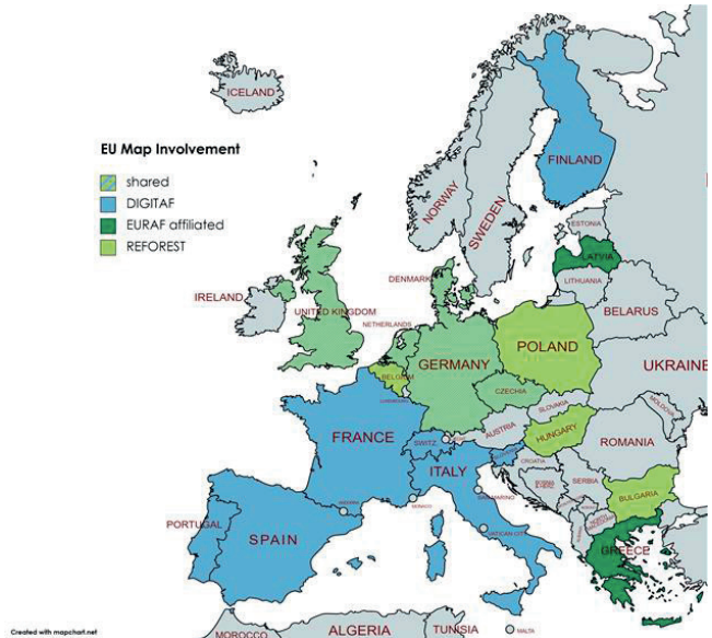
and a uniform database structure together with the use of botanic names and English translations allow for a uniform display of an EU map and evaluation. Funded through the REFOREST project and with the support of the project collaborates in the DIGITAF project is collected, verified, and processed in one database (Figure 1). Based on the experience of the German agroforestry map since 2019 (DeFAF e.V. 2023, DeFAF e.V. 2024), with 142 registered agroforestry sites by the end of 2022, and by using the latest programming technique, an updated online map will be created and its use promoted among national agroforestry associations. To capture the experience of various mappings, an interactive online document to develop the map categories was set up and commented on by the participants. Furthermore, the resulting map features several improvements, both for the user as well as for the administrators. To mention a few: any newly uploaded photo will automatically resized and watermarked to mark its source from the map. Entries can be added from persons interested in setting up an agroforestry system. Such entries can later be changed into an established system on the map. Any alterations by the user will be screened through an administrator needing confirmation. This greatly shifts the responsibility from the organization to the users and makes the map more interactive with the users. The update also involves further improvements to prevent fraud through an email verification procedure and all measures necessary to fulfill data protection legislation. The users decide which personal information should be displayed on the map.
To conclude, the new agroforestry map of Europe will distribute the burden of entries towards individual
users, however, will be managed through national or regional responsible persons. The resulting map data is better protected and its management is structured and transparent. The user experience should be increased through a straightforward GUI and various possibilities for searching, filtering, and viewing.
This abstract is based upon work from project REFOREST and DIGITAF, which received funding from the
European Union´s Horizon Europe Programme under Grant Agreements No. 101060635 and No.101059794.
Acknowledgement
The DigitAF project is supported by the European Union Horizon programme (101059794).
Keywords
Europe, agricultural policy, Land Use Policy, Adoption, European project, Agroforestry Map of Europe,
Agroforestry
Bibliography
– Burgess, P. J. and A. Rosati (2018). “Advances in European agroforestry: results from the AGFORWARD project.” Agroforestry Systems 92(4): 801-810.
– DeFAF e.V. (2023). DeFAF Agroforst-Landkarte – Übersicht zu eingetragenen Agroforstflächen – Stand 31.12.2022. Cottbus, Deutscher Fachverband für Agroforstwirtschft (DeFAF) e.V.: 6.
– DeFAF e.V. (2024). “Agroforst-Landkarte.” Retrieved 23.01.2024, from https://agroforstkarte.agroforst-info.de/.
– EURAF – The European Agroforestry Federation. (2024). “Agroforestry map of Europe.” from http://europeanagroforestry.eu/about/agroforestry-map-europe.
– LIFE AgroForAdapt. (2024). “Agroforestry systems for climate change adaptation of Mediterranean agricultural and forest areas.” Retrieved 23.01.2024, from https://www.instamaps.cat/instavisor/ed9640098936670060d44d6d3481b9f2/LIFE_AgroForAdapt.html#6/42.008/-1.230.
– Palma, J., J. Crous-Duran, A. Graves and P. J. Burgess (2015). Database of agroforestry system descriptions – Report on Milestone 28 (6.3): Database of agroforestry system descriptions: 81.
More info about the oral presentation related to this abstract to come
Want to know more about this presentation? contact@digitaf.eu